

In July/August of 2000 a seismic experiment was conducted at Hill Air Force Base, between Salt Lake City, and Ogden, Utah, by Rice University in Texas.
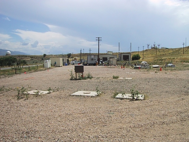
Once upon a time, back when no one knew any better, the Air Force used the
area in the photograph above as a dump site for cleaning solvents used to
clean aircraft parts. Most of the chemicals evaporated, which was the intention,
but some components of the chemicals soaked into the ground. The most notable
of these was trichioro ethylene, or TCE. Luckily for everyone, under the area
where the chemicals were dumped, there was a layer of clay that basically
formed a bowl under the dumpsite and prevented the chemicals from getting
very far. Many years ago it was determined that the area had to be further
contained to make sure that they would not get into the ground water system,
and that the area had to be cleaned up. First a subterranean wall was built
to further contain the chemicals, and then a plant was built to pump ground
water out of the area and process it to remove the TCE. This is the function
of most of the buildings in the photograph. Unfortunately, the subterranean
wall was not build in quite the right place, and TCE was found under the area
in the foreground of the photograph. The purpose of this seismic experiment
was to map the structure of the ground beneath the area to aid in determining
where pockets of TCE may be hiding so wells could be drilled and the chemicals
removed.
This kind of survey is rather common -- oil companies do it all the time to
find out where oil may be hiding. The difference between those types of surveys
and this one is that no one has ever tried to survey this small of an area
using this method, and only to a depth of a few tens of meters. Oil companies
are usually looking at areas of several square kilometers, and to depths of
hundreds of meters. The area of this survey was about 100 meters long (to
about where that van is sitting), and about 30 meters wide. The actual area
was from the foreground of the photograph off in the direction of the antennas
up on the top of the hill in the right-hand portion of the photograph.
2018-03-06