


Thinking back on it, we did a lot! This experiment was conducted by the Fundacion Venezolana de Investigaciones Sismologicas (FUNVISIS), which is like a very small, and only dealing with seismological items, US Geological Survey. FUNVISIS is funded by the Ministerio de Ciencia y Tecnología (MCT), which is similar to the United States' National Science Foundation. The Compania Anonima Venezolana de Industrias Militares (CAVIM) supplied and handled the explosives for this experiment.
In all seven deployments of the instruments were made. Three in and around Caracas, and four in the eastern part of the country.
The first deployment was a mostly east-west line that ran from the southwestern part of the Caracas Valley towards the center of the valley. This deployment used an explosion at a quarry in the Antimano area of Caracas as the source of shock wave energy. This was called the Cantera Profile.
The second deployment was a series of four intersecting lines, each about 5 kilometers long, covering the town of Chacao. This was the Chacao Profile.
The third deployment was a north-south line that ran from the coastal town of Los Corales south for about 50 kilometers over the coastal mountain range, down into and across the Caracas Valley, and into the mountains south of Caracas. This was the Caracas Long Profile.
The purpose of the city deployments was to study the sediment layer beneath the Caracas Valley. It's important to know what is down there so it can be determined how the ground will move during an earthquake. This information can be used to construct buildings and structures that will be better able to withstand the effects. There has never been a detailed study of this size done of the Caracas area. Some measurements were made using the aftershocks from a large earthquake in 1967, but the data was quite sparse, and has since been lost. All that remains of that study is a published paper with a couple of graphs.
Following the city deployments the whole operation was moved east about 300 kilometers to the small town of San Mateo which is about 50 kilometers south of the coastal city of Barcelona.
The first deployment in the east was a 300 kilometer long line from Barcelona, south through the town of El Tigre, past the city of Ciudad Bolivar, and on south another 100 kilometers or so to the end of the road. This was the original purpose of the experiment. The title of this experiment was Estudio Cortical de la Cuenca Oriental, and this was the ECCO Profile.
The second deployment was a very short line about 20 kilometers long east of San Mateo in the Serrania region. We called this deployment the Serrania Short Profile.
The third was a longer line about 70 kilometers long in the same area called the Serrania Long Profile.
The forth, and last, deployment was a partial repeat of the 300 kilometer long ECCO line. It was just so much fun the first time that we couldn't resist the temptation to re-shoot part of it.
Prior to the deployments we did a bit of training. Below is a picture of members of the deployment teams practicing placing the instruments. The trickiest part of the whole operation is getting the red geophones and their cable attached to the Texans. The connector is a bit difficult to work with. After that it's a simple matter of finding some ground that's not too hard, and not too soft -- if you can find any ground at all, which in some cases was a bit tricky for the city deployments -- poking the spike of the geophone into the ground while keeping the geophone pretty close to straight up and down, and hiding the whole thing so people wouldn't stumble on to it by accident, but not hiding it so well that you couldn't find it when you came back to recover it the following day.
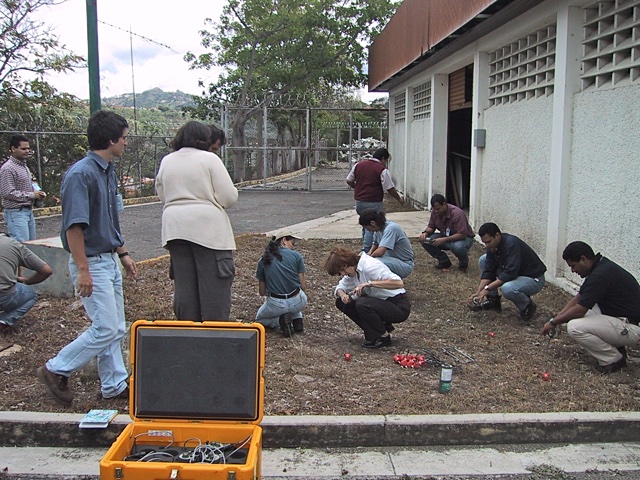
There were eight to ten deployment teams for the experiments that were conducted in the city. Each team was responsible for 20-30 Texans. In addition to those people there were other teams that handled getting the shots set up and set off during the nights. There were four deployment teams for the lines in the east. Those lines involved a lot of driving, but the Texans were usually deployed right along the roads, so the process went a bit faster out there. For the city deployments the Texans were placed inside the fenced in yards of private citizens, or inside the gates of businesses as much as possible.
The majority of the deployment day for the city deployments was spent just being sociable, and convincing the people that you talked to that the Texan was not a bomb. I don't know of anyone that we talked to when I was helping to deploy that didn't at least make a joke about the Texans looking like bombs. I guess they do sorta look like a bomb.
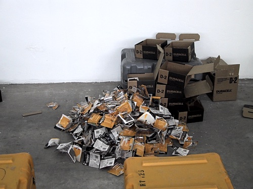
Before the Texans could be programmed and deployed they also had to be loaded with batteries. Each Texan takes two D-cell batteries. With about 200 Texans that added up to more batteries than I had fingers and toes to count on. One set of batteries lasted for all of the deployments in Caracas. They were then changed before we moved to the east. The second set lasted for all four deployments in the east.
2018-03-03